All Activity
- Past hour
-
Lol
.thumb.png.acfca5d0961cf6e1f8ba94a50fa934ee.png)
-
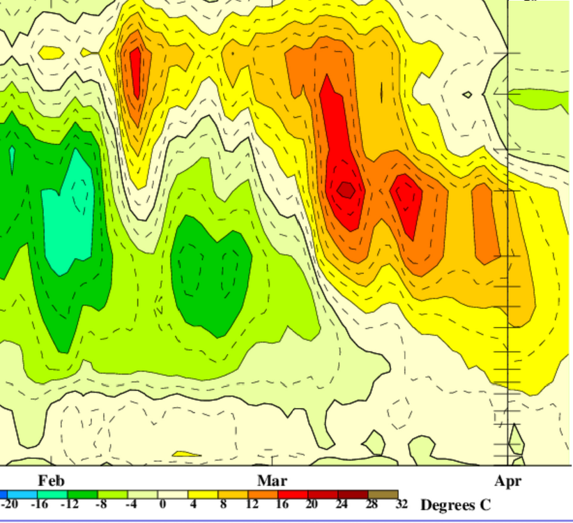
HAHA. ... might have helped if i included the y axis (height)... but the top is higher in elevation ...etc. just saying that a, it's not abundantly clear this was truly a down migrating warm anomaly associated to the SSWs and b, probably a hint to that uncertainty ( if not 'no' ), the AO didn't really demonstrate a big negative phase forcing - the correlated index depression doesn't go way up and down like that... the whole behavior is whack really.

-
Don’t mind me if you see me in the golf course or driving range practicing my back swing lol
-
Looks like DTW got 1.8" of snow from last night's event. And it appears to have been a general 1-2" snowfall across all of the Detroit area.
-
Got a bit greedy with how last year's spring went (if I recall a good amount of 60's and 70's?) and forgot this weather is very much on par for a typical April here...just a few more weeks
-
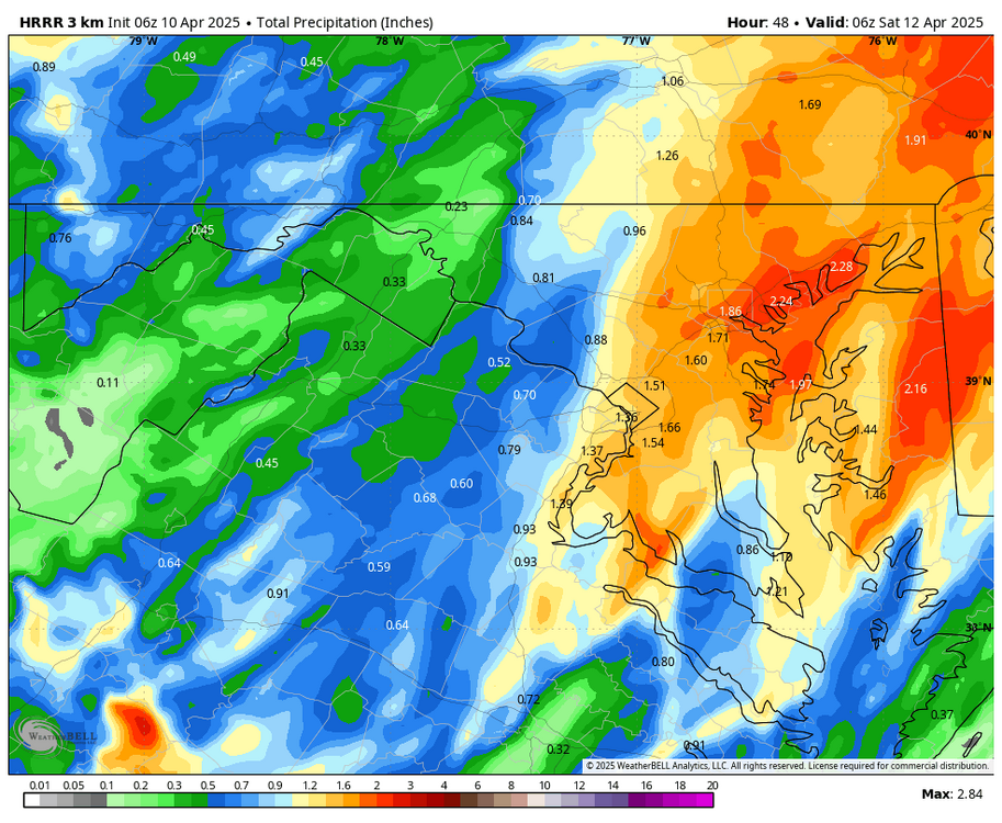
12Z HRRR shifted heavier rain westward compared to 6Z.

-
Getting back to the ENSO discussion. The SFB will be even more in play than we typically see this time of year. As this 1+2 forecast miss suggests that the models are really struggling with the emerging dichotomy between the CP and EP in recent years.Time to just sit back and watch how this unfolds in the coming months.


-
A snowy aftrn yesterday, but nothing stuck. A little on the grass this morning with a mix falling. Temps hitting mid-upper 50's(60?) this weekend with some rain moving in (ending with a mix), then back into the 40's next week. Will be nice when the sustained warmer wx settles in next month.
-
That is entirely possible, absolutely can't be ruled out. Guidance really is all over the place with the pieces and exactly how this evolves.
-
WB 6Z EURO looked ok...

-
All I got out of this is that you have camel toe
-
Yes, IMO.
-
Unclear (bold) .. to me, anyway. I mean at a glance this ( below..) looks a little like a down-welling mass, but not convincingly as such compared to other more obvious/verified examples. The morphology of this is kind of screwy... It really looks a little like both down-welling, and just simultaneous multi-layer warming took place. Either way, clearly some residual thermal inversion sort of "spilled" ( right side ) of this graphical illustration ( source: https://www.cpc.ncep.noaa.gov/products/stratosphere/strat-trop/ ) ... pretty low, low enough not to be a terrible correlation with blocking. However, the AO did not respond so well (farther below). If anything, smoothing out these camel toe migrations the mean's been rather positive. So it's all unclear
-
This looks like complete poop on the mesos. Baroclincity ain't there. The surface players are also weak, surface high and low. Temps to our north and west are in the 40's... I don't see the driver for a strong CCB into CNE/NNE. At all. The mid level low occludes over VA and starts spinning itself out... I think we see scattered decaying precip shield as this moves north of the CT coast. Dynamics are absent. 1024 mb high in northeastern NB; 1008 mb low 100 miles SE BM. Synoptic pressure gradient on par with Zzzzzzz sensible weather....
-
Wild how we can't get significant rain across the area.
-
Soundings aren't impressive on the HRRR. Would really like to see a good thump into the DGZ. Kind of shallow lift.
-
At least there seems to be some shed of light at the end of the tunnel. If it isn't light at least we have climo in our favor.
- Today
-
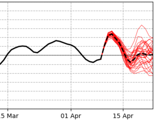
I haven't paid much attention to this but I wonder if the recent SSW event (did it actually occur?) played a big role here. I know it's not too uncommon to get one final major SSW event between like late February and mid-March so maybe the years where that occurs and it does so to enhance block potential in our hemispheric domain...if that is what leads to these tendencies? But its wild how common this is or can be during April...almost like a delayed response to whatever is going on during the month of March.
-
It's a good question ... it's endemic to winters lately, since ~ 2002 with more coherency, where compression in the mid or core winter heights times limits the middle spectrum cyclones, but interestingly ... the rare bombs have more power.. Anyway, as the seasonal onset of lessening gradient (spring) sets the flow more flaccid ... there's a window there whence we observe more late season blocking. More energy can then get expressed at smaller scales for one, lending to these types of systems. But also, just in general these cold meander patterns and associated storms make springs ( autumns too ) become more wildly variable between cold snaps and warm interruptions. This year appears to be much of this going on, but super-imposing is this lingering planetary Rossby signal, the same one that kept us chilly ( relatively so...) much of the way, anyway. When the flow is compressed, that speeds up the baser wind velocities - it's like an exchange. As we add one or two more of those 500 mb height lines in the total gradient, the balanced geostrophic wind speeds physically increase. Physically, the speeding up is likely proportional to some negative interference quotient that the models seem to have issues with, particularly in the extended performance. They seem to normalize the neg out - it may be partial in why we have trouble maintaining amplitude.
-

Central PA Spring 2025
Mount Joy Snowman replied to canderson's topic in Upstate New York/Pennsylvania
This is actually pretty damn cool. Thanks for digging that up and sharing. Incredible. -
6z euro says we don’t get there. Icon from earlier this week is going to be “wrong”, but guidance partially moved toward it for sure.
-
Storm Chaser Adam Lucio rotSpsndeolm1m3434i1u0titim89f04itifg8h103t5hchiml2atami6i81 · We've seen almost a record number of tornadoes this year. Here is how it breaks down by state through April 7th. Surveys continue, so numbers may keep going up in some areas! #MississippiMississippi is leading the charge, followed by #Missouri and #illinois.
-
 Funny how you again only cherry pick one station......again the entire county was chilled and altered to average temperature levels that almost no stations in the entire county ever recorded for 80 to 100 years.
 -
Why couldn't we get this evolution 2 months ago ughhhhh. oh well hopefully its on to EML tracking soon
-
While it looks like we have seen our last measurable snow of the season....it is not unheard of to see accumulating snow here in Chester County during this full first month of spring. It has been several years since 2018 that we have recorded measurable snow. But on this date back in 1894 we were in the middle of our largest April snowstorm on record. Per the Weather Bureau observer (see his handwritten observations below) the heavy wet snow began falling at Coatesville at 10am on April 10, 1894 and continued to snow until 2pm on April 12th. By that time 29.2" of snow had fallen. Of note the temperature during the entire snowstorm stayed above freezing at between 33.0 and 34.0 degrees.


.png.145453aab27f2bf71b57f7edcc95aaf7.png)

.thumb.jpg.049f4a7f726ada07e8cd30bd17e713cb.jpg)


