All Activity
- Past hour
-

-
Will I ever get to use my recurring Saturday morning tee time? 0-2 so far this year.
-
Our snow deficit was not due to a lack of cold this season. MDT had Below normal temperatures from December through February. The lack of meaningful precip limited our snow chances. We never had a moisture laden storm attack the numerous cold air masses. Despite the lack of good snow totals, as many have mentioned, we still did have a lengthy period of snow cover due to the sustained cold for several weeks.
-
Wagons north
-
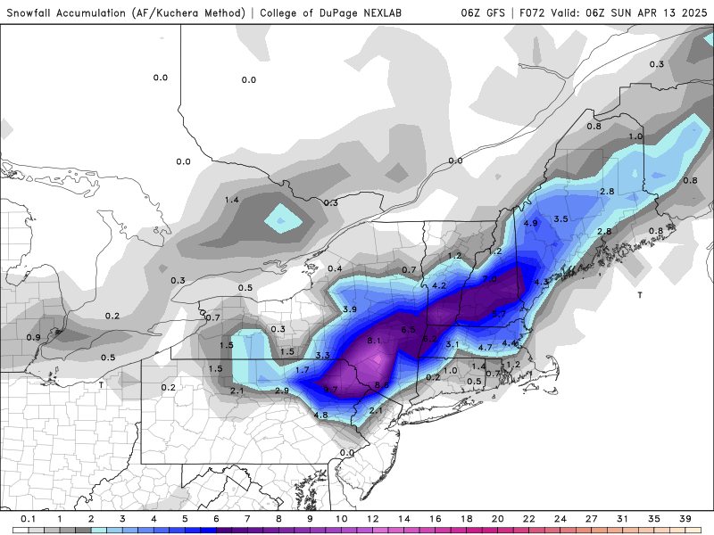
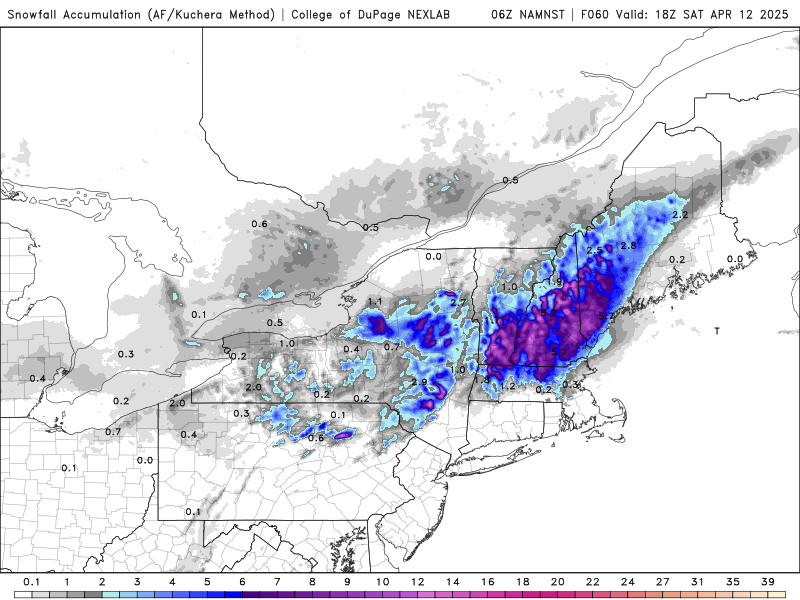
We’ll take the under on kuchie, but even the depth maps are 1-3”.
-
Upper 20s this morning. Blah.
-
This weekend is dung
-
Heat on every morning and evening…spring is great in SNE this year. Horrid!
-
Enjoy the snow
-
Looks great
-
Been below freezing for the last 5 mornings in a row…but we are being told it’s over the last few weeks, and warmth is here. I haven’t seen it however.
-
Next weekend if Euro cutoff idea is correct for following weekend
-
Will be a nice afternoon today. 50’s. Outside of SE MA and islands, the weekend is also trending drier. It’s not done. A lot deamplifying factors for this thing, after it starts spinning out over the mid Atlantic.
-
Definitely some wet flakes up above us. I had some yellows over MBY and hardly anything falling.
-
66° for Dover?
-
Yes, the new season starts on Sunday lol
-
We won't be below 50 for highs again after this week.
-
Yes this was actually mentioned in regards to the January 2016 behemoth, it was stated that the snowfall was 20% higher than it would have been in a pre ACC world.
-

2025-2026 ENSO
40/70 Benchmark replied to 40/70 Benchmark's topic in Weather Forecasting and Discussion
BTW, a warming climate also holds more moisture, so its not outlandish to think that the modern snowfall ceiling along the north east coast is actually higher than it was 50-100 years ago...however, I understand the limitations and agree that moderate snowfalls are growing less frequent due to said warmth. -
2025-2026 ENSO
40/70 Benchmark replied to 40/70 Benchmark's topic in Weather Forecasting and Discussion
I'm not familiar with that event. Yes, winds are another factor....high winds fragment the dendrites, which hinders accumulation. -
Heavier than I expected it to be when looking at radar
-
It maddens me that this historic storm is never mentioned as one of the all time greatest so I will keep mentioning it: February 1920, three days of heavy wintry precip, more than 1.00" LE each day for three days, 4.50" plus total LE, 17" of frozen precip, Manhattan looked like it was invaded by icebergs. The only reason it didn't cause the same or more level of destruction as March 1888 did is because the city finally decided to bury the powerlines after March 1888 happened.
-
Why does it seem like western ridge/eastern trough patterns seem to last for weeks, but once said ridge moves east, it's transient, and the cold, unsettled trough pattern returns? After the rainstorm, we get two nice days in the 60's before a return to a 49 degree high next Wednesday again.
-

E PA/NJ/DE Spring 2025 Obs/Discussion
pl0k00n111 replied to PhiEaglesfan712's topic in Philadelphia Region
But I want to do projects in my yard. -
There are also other factors, Ray, like high winds are not conducive to high ratios, among other factors. We can use other 2" LE storms as our guide, I've not found the ratio to be more than 12:1 in any case so I think that should be the upper bound here. What do you think of that massive three day event in February 1920 with 4.5" LE though? It was a mixed event but 17" of snow/sleet out of that is still historic and Manhattan looked like it was invaded by icebergs from the images I've seen lol.


