All Activity
- Past hour
-
ACATT will ride the GFS everyday all day , even when it disagrees with its own ens
-
Here comes a Tuscaloosa-Birmingham type to take out all the indoor walkways in Minneapolis.
-
already commented about it in the May thread
-
I just got a serious of violent gusts out of nowhere.
-
It's howling now.
-
Tony, -After a cold winter, March was mild and all but one day Mar 24th through April 4th had 80s! The consistent BN chill didn’t restart til 4/17. From then through August, most dailies were BN! Mid May had a 3 day period with lows in the 40s. -1909-10 was the middle of a 3 year long La Niña. After that 3 year period came 1911-12, a moderate El Niño with several significant wintry precip events and a cold JF. -Sunspots: 1909-10 was coming off the 1906-7 peak of the prior cycle, which was one of the two weakest cycles since after the early 1800s Dalton Minimum. The next cycle that was about as weak wasn’t until the one with the very weak min in 2008-9! -Other Atlanta measurable snows were 0.6” (4/4-5/1891), 0.2” (4/11/1918), and 1987 (4/3)(measurable northside but only T at KATL).
-
O’s have some soft opponents in May, but ooof. They could be in a deep hole going into summer.
-
.thumb.jpg.6a4895b2a43f87359e4e7d04a6fa0d14.jpg)
Central PA Spring 2025
Yardstickgozinya replied to canderson's topic in Upstate New York/Pennsylvania
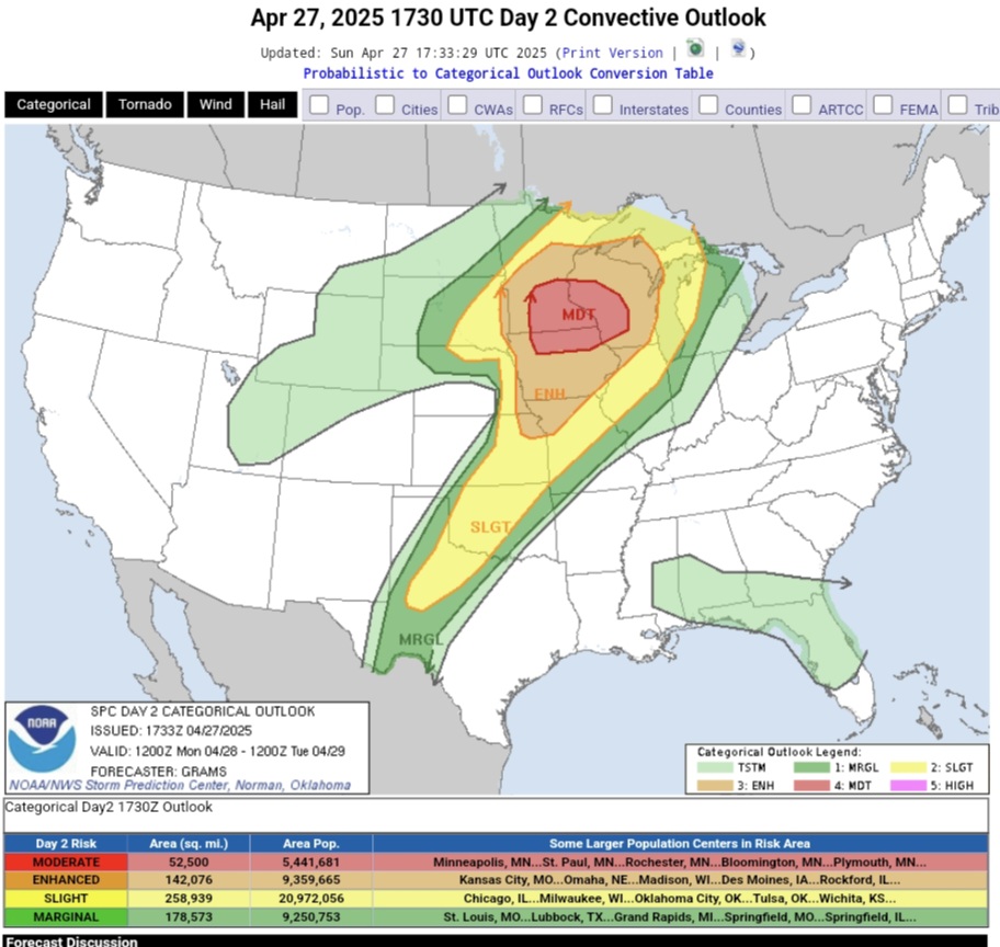
This was sniffed out at least a week ago. I don't believe I have seen a mention here. https://www.spc.noaa.gov/products/outlook/day2otlk.html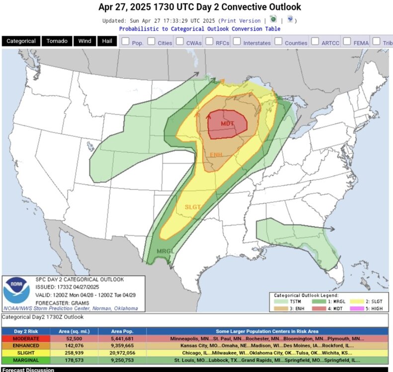
-
It’s been so bad this year. Makes even a decent temp day miserable a lot of the time
-
Reminds me of living in Milwaukee. Miserable.
-
That's surprising as it was so much colder back then, and some of the biggest events were in that period, earlier, but withing 20 years, or so. How many cold snaps occurred that spring? Or was it a true outlier? It just seems so late in the spring to be a one off. But then we had a day or two in the 70's in July or Aug a few year back, and don't remember ever seeing that before. A true one off. I remember after TD Alberto dropped all that rain, the rest of the summer was comparatively mild, but not in the 70's mild. I guess climo works in mysterious ways, lol.
- Today
-
And if correct will also keep things on the drier side of normal on a NW flow.
-
You better turn the AC back on by Tuesday.
-
Same. Barely looks like it rained
-
Lfg
-
Fucking sick of these windy days.
-
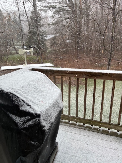
Still snowing.
-
I was one of the unlucky spots -- only 0.15" here. Not enough to give things a good watering. Thursday night into Friday looks like the only decent chance of rain. Other than that the next week and a half looks dry. I'll be needing to water the vegetable garden a lot.
-
This wind can go kick rocks though
-
Euro has upper 80’s- low 90’s Mayorch 7-8
-
Solid model agreement over the extended on this 12z run ... Hey, ... maybe we can get one of those entertaining fights between Kevin and Kdxken going !

-
URGENT - WEATHER MESSAGE National Weather Service Baltimore MD/Washington DC 223 PM EDT Sun Apr 27 2025 VAZ025>027-029-280230- /O.NEW.KLWX.FR.Y.0003.250428T0600Z-250428T1200Z/ Augusta-Rockingham-Shenandoah-Page- 223 PM EDT Sun Apr 27 2025 ...FROST ADVISORY IN EFFECT FROM 2 AM TO 8 AM EDT MONDAY... * WHAT...Temperatures in the mid 30s will result in frost formation. * WHERE...Page, Shenandoah, Augusta, and Rockingham Counties. * WHEN...From 2 AM to 8 AM EDT Monday. * IMPACTS...Frost could harm sensitive outdoor vegetation. Sensitive outdoor plants may be killed if left uncovered.
-
Our first heat typically shows up near Memorial Day weekend so this would be right on time. Looking like wet and somewhat cool first half of May?
-
Ineedsnow would be nude right now.


.thumb.png.e1f898d009b2415a204433df288e6f2a.png)


