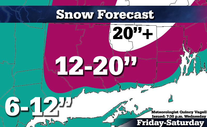
Snowfall Forecast: February 8-9, 2013
 I just want to quickly share my latest thoughts for Connecticut and surrounding areas.
There's little doubt that a strong storm with plenty of precipitation will impact the tri-state area and southern New England Friday into early Saturday, but there are still a few details to discuss.
Concern #1:
Mixing along the shoreline. An initially "warm" boundary layer may cause mixed precipitation to fall near the Connecticut shoreline and coastal Rhode Island for several hours. With that said, as low pressure really intensifies southeast of Cape Cod, winds shift to the north and cold air pours on down. This will suddenly change everyone back to snow, even across eastern Long Island.
Concern? Well, right now I have a wide range of 6 to 12 inches in the forecast. I'm leaning on the higher end of those numbers for coastal sections of Conn. and R.I., but there's still some room for change. These numbers could go higher, although I really doubt they'd trend lower...
Concern #2:
Deformation band of intense snowfall. These bands can be difficult to predict with accuracy and a slight shift could be the difference between 8 inches and 18 inches. With that said, I expect this band to impact the eastern half of Conn., especially areas like Tolland, Union and Woodstock that stay all snow and hang onto precipitation the longest. In that band, I am predicting more than 20 inches of snowfall.
Bottom line...heavy snow, strong winds and coastal flooding are likely. I can see widespread blizzard conditions verifying for IJD, ORH, BOS and surrounding areas. (many areas not included in this map, such as northeastern Mass. and southern N.H.


0 Comments
Recommended Comments
There are no comments to display.
Create an account or sign in to comment
You need to be a member in order to leave a comment
Create an account
Sign up for a new account in our community. It's easy!
Register a new accountSign in
Already have an account? Sign in here.
Sign In Now