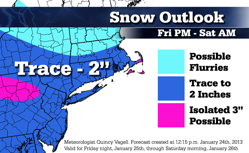
Snowfall Forecast: January 25-26, 2013
 This isn't really a big event, but due to the amount of discussion it's had, I felt a map was warranted.
Low pressure moving through the Great Lakes brings an usual push of generally light snow towards the Appalachians. A new area of low pressure is forecast to form east of the mid-Atlantic region, enhancing snowfall amounts ever so slightly around the coastal plain. This map does not show it, but light snow should extend southward into Virginia.
I believe that most areas will see an inch or less of snowfall, with interior Mass. seeing little or no snow at all. I'm not even all that confident for 3" amounts, but I added them as a potential outcome for northern Pennsylvania, the outer Cape (Cod) and the Islands of southeastern Massachusetts.
The column is fairly cold, from the surface right up through 850mb and 700mb, promoting snow growth and higher than "typical" liquid to snowfall ratios. I could see 15:1 ratios on the shoreline and 20:1 further inland. The end result is a light, fluffy snow that pretty much sticks on contact to most surfaces.
Basically, most areas may see up to an inch, with the highest probability of 1"+ amounts occurring along and south of a line from Binghamton to Bridgeport to Groton to Providence to Taunton.


0 Comments
Recommended Comments
There are no comments to display.
Create an account or sign in to comment
You need to be a member in order to leave a comment
Create an account
Sign up for a new account in our community. It's easy!
Register a new accountSign in
Already have an account? Sign in here.
Sign In Now