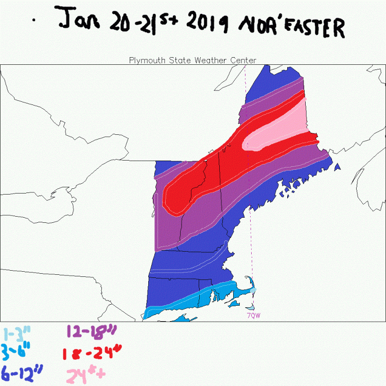
Preliminary Snow Map for January 20-21st Nor'easter
The next name on the Weather Channel's annual Winter storm name's list is Winter Storm Harper, he is currently badgering the West Coast of the US. Models bring his heavy precipitation and moisture to the New England area in the form of snow for most, and snow/rain mix southeast of BOS to Hartford line. My snow map is the latest blend of guidance, and if the UKMET solution is right, I could be bust pretty low on the South Coast of MA, RI, and CT and it could be in the form of all snow in which 24-36" amounts would be plausible from NYC to BOS. I hope for that solution, but I think it might be warm enough for a change to rain and so I am going conservatively with a 3-6" amount from New London, CT to Cape Cod, MA. The map is pretty self-explanatory. Oh, and more historical storms are in the chute.


0 Comments
Recommended Comments
There are no comments to display.
Create an account or sign in to comment
You need to be a member in order to leave a comment
Create an account
Sign up for a new account in our community. It's easy!
Register a new accountSign in
Already have an account? Sign in here.
Sign In Now