Snow Forecast: CT and Surrounding Areas
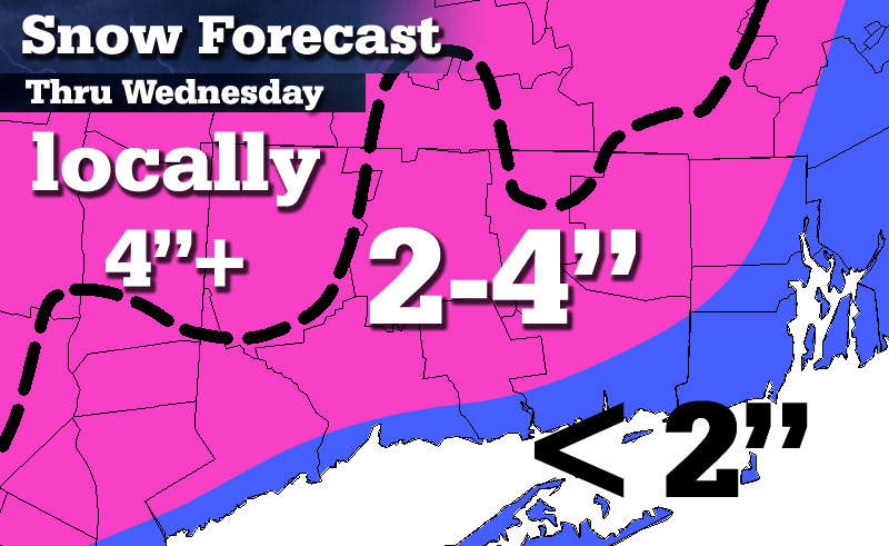
 I see this event as a widespread 2-4 incher across most of interior SNE. The tough call comes along I-95 for BOS-PVD-GON, as often is the case. I do think most areas even along the South Shore get a thump of snow/sleet at the beginning.
I'm not really all that confident on widespread 4"+ amounts, but I've outlined an area with a black dotted line that could see locally 5-6 inches.
I also expect precipitation to quickly shut off in the morning (by 7 or 8 a.m. across much of Connecticut) and taper to drizzle near and SE of I-84 with pockets of "snizzle" or flurries/freezing drizzle across the higher terrain.
Connecticut Forecast:
On the shoreline...(< 2 inches)
Although there may be a period of snow and sleet, temperatures near the ground will likely remain above freezing through most of the event. Combine this with with a changeover to plain rain and areas near the coast should see less than 2 inches of snow/sleet.
Inland...(generally 2-4 inches)
Most areas should see a period of moderate snow before a changeover to sleet. Precipitation may actually end as a period of drizzle late Wednesday morning, with pockets of freezing drizzle in the hills. Before the changeover, generally 2 to 4 inches of snow/sleet is expected.
Highest elevations...(locally 4"+)
Due to colder air in place, Litchfield County and northern Tolland County may stay near or below freezing throughout the entire event. The end result is NEAR 4 inches of snow with localized totals that could reach perhaps 5 or 6 inches.


1 Comment
Recommended Comments
Create an account or sign in to comment
You need to be a member in order to leave a comment
Create an account
Sign up for a new account in our community. It's easy!
Register a new accountSign in
Already have an account? Sign in here.
Sign In Now