Tuesday Tornado Threat – Sunday PM Update
A tornado threat is still being closely monitored for Tuesday, as computer model forecasts and trends have been fairly consistent with the potential for severe weather on February 2nd for quite some time. There really are no major changes from the previous forecast, but there are still a few question marks that need to be resolved. Some new high resolution model guidance that came out Sunday night suggested that the threat may be leaning towards a higher impact event than a lower impact one.
Overview of setup and tornado potential:
- Low pressure tracks into the Midwest on Tuesday
- Warm, moist air to the south and southeast
- Strong wind fields aloft with this system Thunderstorms expected 2nd half of Tuesday
- A few tornadoes are probable
- There is a strong, long-track tornado threat
- Area of focus is still the Lower MS Valley to TN/OH Valley
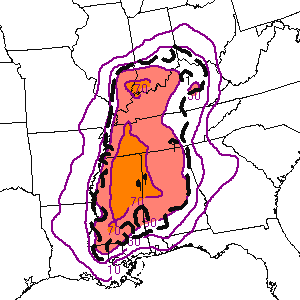
The purple area shaded below is where tornadoes are most likely on Tuesday. A conditional “wildcard” risk exists from parts of central to southern Mississippi into western Alabama, but confidence is not very high yet in discrete supercells being able to develop in that area.
PROS – Favoring a tornado event: Speed shear is very favorable for tornadoes, with more than 50 knots of 0-3km shear and 30+ knots of 0-1km shear likely. The directional shear is decent, with a southwest flow in the mid and upper levels with winds locally south to south-southeast in the warm sector. A delayed start to convection will likely result in a discrete thunderstorm mode early on. If the warm sector has less convective contamination early in the day, that could also allow instability to bump up a bit from recent forecasts. Moisture return is very solid for February, as 60-65+ degree dew-points are likely across much of Mississippi, Alabama and western Tennessee. A few analogs have consistently showed the potential for a tornado outbreak given the forecast setup. The 21z SREF and 00z NAM/RGEM also looked a bit more impressive than previous model runs.
CONS – Limiting factors and areas of question: Capping could ultimately delay the start of convective initiation, resulting in sparse thunderstorm activity Tuesday afternoon. It is unclear how many discrete cells will form in the favorable environment and how large of an area that will cover. The upper level and surface pattern is not ideal, as the trough is more negatively tilted than what is optimal for an outbreak and the surface low will already have become occluded by early Tuesday. Near-neutral height falls across central Mississippi to central Alabama would limit the ability of storms to initiate early in the event. Although mid-level lapse rates are favorable near the Mississippi River, they become less impressive with eastward extent, based on most model projections. Any mesoscale boundaries that setup on Tuesday could also be factors. Instability is another issue. Although significant levels of instability are not necessary for a dynamic winter event in Dixie, forecast CAPE for Tuesday still appears to be marginal to modest.
Sunday night model data: The 00z 4km NAM was very concerning, showing an extensive line of supercells developing by early Tuesday evening from Mississippi to Kentucky. Although the NAM did not really show any convective initiation to the south across central Mississippi to western Alabama, this the environment in that area will be supportive of tornadoes. It’s just that a lack of forcing and little to no height falls make this a conditional threat. With that said, the 00z RGEM does imply discrete to semi-discrete storm development on both sides of the Mississippi/Alabama border area. The NAM hinted at this, especially with some locally backed winds and elevated severe weather parameters. The GFS did not show any major trends one way or the other, but with its coarse resolution, it is not being used as a primary model of consideration. The SREF has also been gradually trending more impressive with the environment over the region for Tuesday.
The analog data has not changed much either, with January 19th, 1988 still being the top analog of choice. “It only takes one,” meaning that even if this event is largely a dud, the environment could easily support a significant, long-tracking tornado. The odds of at least one strong tornado are increased to 70% with this update.
Periscope video briefing on this potential eventhttps://www.periscope.tv/w/aX7aEDFsWktwcm1ud29Fbm18MWRqR1hhZFJrcE9KWt2OHgSuGqDHLDJbVuDezoEH2_k4l2FthEZuqXLrLa7J


0 Comments
Recommended Comments
There are no comments to display.
Create an account or sign in to comment
You need to be a member in order to leave a comment
Create an account
Sign up for a new account in our community. It's easy!
Register a new accountSign in
Already have an account? Sign in here.
Sign In Now