Tornado Threat for Tuesday, Feb. 2nd
The threat for severe thunderstorms, including tornadoes, continues for Tuesday. The area of focus is the lower Mississippi Valley into portions of the Tennessee Valley and lower Ohio Valley. Nothing significant has changed from the computer models, suggesting that a severe weather event is still probable Tuesday into Tuesday night with at least a few tornadoes possible. There are still details to nail down, but at least a few key ingredients are in place for tornadoes across the region.
Thinking since Friday morning’s update has not really changed. The computer models have gotten into better agreement with timing, as the Euro stopped its westward/slower trend and both the GFS and NAM are similar with the overall timing. There still are big questions about instability, as greater instability than forecast would support a higher-end event. As usual, the GFS and to some extent the Euro show marginal to modest instability, while the NAM (as often is the case) is a bit more robust. Wind shear, both directional and speed, is very favorable for tornadoes and the overall upper level pattern is supportive as well. Backing of low-level winds to the south/south-southeast should be coupled with southwesterly winds in the mid and upper levels. The one notable trend on the models has been for more of an initially discrete mode for convection Tuesday afternoon and early evening. If initiation is delayed, that could allow for further daytime heating, juicing up the setup even more. Also, if the storm mode is more discrete versus a squall line, the tornado threat would be elevated. It appears that the storm mode will eventually trend to a squall line regardless, especially as the shear pattern becomes more unidirectional overnight.
Current thoughts: Discrete and semi-discrete thunderstorms fire in far eastern Arkansas and northeastern Louisiana Tuesday afternoon. The storms moved northeast and have the greatest threat of producing tornadoes from near the Mississippi River, northeastward to southwestern Kentucky, western Tennessee, northern Mississippi and northwestern Alabama. Given the expected wind fields, strong, long-tracking tornadoes remain a possibility. Odds for at least one strong tornado are set at 60% with this update.

A tornado threat exists outside the red shading above, mainly in two areas. One being near the triple point in eastern Missouri to southern Illinois, but meager instability suggests this threat is highly conditional. Also, a few discrete cells could fire in the warm sector farther south in Mississippi (possibly western Alabama), but weak height falls suggest that the best forcing will be farther northwest.
Once more high resolution data can be reviewed Sunday night, hopefully more details on the magnitude of this threat can be given with higher confidence. When reviewing analogs of similar setups in the past, most have produced at least some severe weather, but when instability was moderate to strong, such a setup often produced a significant tornado outbreak. At this point, this appears to be a low to moderate tier winter tornado event, not too uncommon for early February. One recent trend that may support a higher-impact event is that surface temperatures on Saturday were much warmer than forecast across much of the Mississippi Valley and Ohio Valley. If this trend were to continue in the coming days, it could allow for more instability than currently forecast on Tuesday, enhancing the tornado threat.
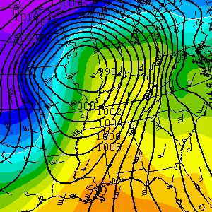
To give a rough idea of what this event might look like, below is a reasonable analog from the January 19th, 1988 event. That setup also had lower end instability, especially over western Tennessee. It's not uncommon for winter Dixie events with high shear/low CAPE to produce tornadoes, some strong and long-tracking.


0 Comments
Recommended Comments
There are no comments to display.
Create an account or sign in to comment
You need to be a member in order to leave a comment
Create an account
Sign up for a new account in our community. It's easy!
Register a new accountSign in
Already have an account? Sign in here.
Sign In Now