Groundhog Day Severe Threat: 1st Thoughts
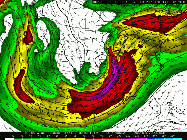
A notable threat of severe thunderstorm activity in early February has been showing up in the models for several days now. As the event gets closer, confidence is increasing that a setup favorable for severe weather is likely to occur. However, there still are a lot of details left to be nailed down. The broad pattern involves a vigorous trough in the jet stream digging across the Four Corners region on Monday, February 1st and swinging east to northeast across the United States into Groundhog Day. The greatest severe weather threat will be focused on where energy around this trough ejects with the orientation (tilt) of the trough being a factor of important consideration.
Lee-side cyclogenesis is likely on Monday across the southern High Plains with low pressure rotating from the Texas/Oklahoma vicinity into the Middle Mississippi Valley and eventually the Great Lakes. Given the low-level jet projected with this system, ample moisture return should bring 60+ degree dew-points northward into the Gulf Coast states. Instability forecasts have varied from weak to modest and the shear signal has been significant, with a sizable area of 50+ knots of 0-6km shear likely.
Similar setups in the past (analogs) have mixed signals, with some showing significant severe outbreaks and others with little to no severe activity. My main focus at this point is the orientation of the trough. A more negatively tilted trough will yield an increasingly unidirectional wind field. If the trough is closer to a neutral tilt or slightly positive, that would maximize the amount of directional shear. The trends appeared to favor the trough becoming negatively tilted on Tuesday, February 2nd, meaning that the storm mode could get messy and trend toward a squall line. The new 00z ECMWF shows a trough closer to a neutral tilt as the upper level flow is southwesterly, not south-southwesterly. If this were to be a hiccup and the trough is more negatively tilted, then the severe threat will not be maximized. It is important to note that severe thunderstorms, including tornadoes, will still be possible in this scenario, but if the ECMWF is correct, we may have a more significant threat to monitor.
Based on the latest data, I would expect an isolated, conditional severe threat to develop across the southern Plains late Monday into the overnight, mainly from parts of North Texas into the eastern half of Oklahoma. Given cold advection and steep mid-level lapse rates, the major threat would likely be large hail, although damaging winds and perhaps a couple of tornadoes would also be possible. Tuesday is the day of focus, as any discrete to semi-discrete thunderstorms that develop in the warm sector could become tornadic. It appears that this area will encompass northeastern Louisiana and eastern Arkansas into Mississippi, far southeastern Missouri, far southwestern Kentucky and western to middle Tennessee. Although the threat could punch north into southern Illinois, southern Indiana and more of Kentucky, meager instability amidst an increasingly pinched warm sector, there is lower confidence in this scenario. Also, the severe threat could reach Alabama later in the day, but the last several runs of the ECMWF have suggested a somewhat slower evolution, keeping the threat a bit farther west, perhaps only reaching northwestern Alabama.
With all of this said, severe weather seems likely on Tuesday with at least a few tornadoes. The wind fields would support a strong tornado. If one or a combination of the following conditions are met, then this setup could turn into a higher-impact event with numerous tornadoes, some strong and long-tracking: More instability than currently forecast would support a more robust setup, particularly in terms of localized vs. larger scale. A near-neutral or even slightly positive tilted trough would increase the amount of directional shear. Discrete thunderstorm development in the warm sector, especially early in the day on Tuesday, would suggest an elevated tornado threat.
First thoughts:
-Conditional threat of a tornado or two late Monday night/early Tuesday.
-At least a few tornadoes on Tuesday; better than 50/50 odds of a strong tornado.
-Tornado threat is maximized on Tuesday from far northeastern Louisiana and eastern Arkansas into northern Mississippi, western to middle Tennessee, far southeastern Missouri, far southwestern Kentucky and northwestern Alabama.


0 Comments
Recommended Comments
There are no comments to display.
Create an account or sign in to comment
You need to be a member in order to leave a comment
Create an account
Sign up for a new account in our community. It's easy!
Register a new accountSign in
Already have an account? Sign in here.
Sign In Now