Severe Watches Lacking in 2015
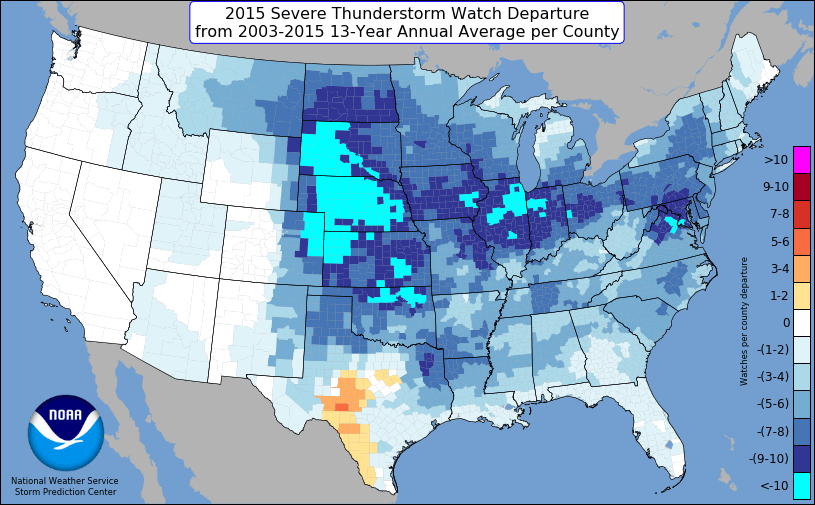
For the fourth year in a row, overall severe thunderstorm activity, including tornadoes, finished below average across the Lower 48. This graphic shows the severe thunderstorm watch departure from the 13-year average. The vast majority of the U.S. saw at or below average numbers of severe thunderstorm watches. The greatest departures from average were across the central Plains into parts of the Midwest. The only state with more severe thunderstorm watches than average was Texas, with a higher instance of watches over parts of central to southern Texas. What was the cause for this, aside from the seemingly long-term lack of severe thunderstorm activity?
The 2015 severe weather season actually got off to a relatively fast start from late March into early April, remaining active into much of May. Attention shifts toward June, which is usually the the peak of the season. June 2015 featured substantial ridging across the western U.S. While not the sole factor, that ridging was a big player in the relative lack of severe thunderstorm activity into June. The severe season climatologically focuses in to parts of the central and northern Plains in June, but the 500mb height pattern in June 2015 was not the most favorable for severe thunderstorms. Some troughing evident over the Great Lakes favored multiple severe weather events across the Midwest and Ohio Valley. However, even here, the season, overall (not in all cases), was on the quieter side.
Above image shows 500mb heights and anomalies for June 2015.
The overall tornado activity in 2015 was below average, but some parts of the country did see an increase in activity compared to recent years. Portions of Iowa and northern Illinois saw a very active tornado season. This included an early season outbreak on April 9th and a fall event on November 11th. Texas also saw an active season, particularly in North Texas. The High Plains saw a broad area of increased activity, particularly from the Texas panhandle into eastern Colorado and western Kansas. The other part of this graphic that stands out is the lack of tornado watches across the Deep South. Given recent trends and forecasts, it is conceivable that the severe season over the Gulf Coast states, including Florida, may remain on the active side over the next few weeks. Deeper into the year, it is a bit more unclear if March and April will see an uptick in activity across Dixie Alley. Only time will tell.


0 Comments
Recommended Comments
There are no comments to display.
Create an account or sign in to comment
You need to be a member in order to leave a comment
Create an account
Sign up for a new account in our community. It's easy!
Register a new accountSign in
Already have an account? Sign in here.
Sign In Now