Severe T-Storm Threats: May 14-16
 The relatively active month of May looks to heat up again in the coming days. After a lot of severe thunderstorm activity last week, the first few days of this week have been on the quieter side. I am looking ahead to three days in particular for the next notable severe weather threats.
Sleeper Thursday: This day has not been on the radar for most, but offers some potential, even if it is lower-end and in a relatively small area. I am focused on western Texas for isolated supercell/severe potential late Thursday afternoon into the evening hours. A small perturbation/vorticity lobe is modeled to pivot from eastern New Mexico into western Texas late Thursday. At the surface, modest daytime heating will likely result in an area of 1000-2000 J/kg SBCAPE, coupled with approximately 30 knots of 0-6km shear. Although the shear is somewhat marginal for supercell potential and the aerial extent of overlapping parameters is small, the higher resolution models do favor clusters of storms developing in this area.
Some red flags include weaker winds aloft and storm mode/coverage, but an increasing low-level jet and backing winds around 00z may provide a small window for tornado development. What gets my attention about this event is that it is under the radar and in favorable chase terrain. I do not expect a lot of people to be out and the High Plains have featured several beautiful structure and tornado events this season, so I am not sure I can pass it up. Worst case, I would bail and head north, to get into closer position for Friday.

Localized outbreak on Friday:
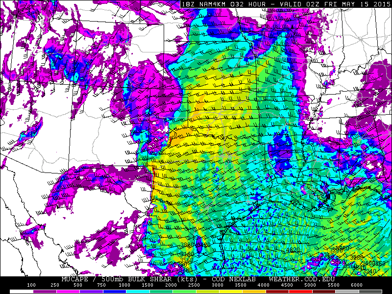
The model guidance continues to show a strong signal for a severe weather on Friday, with an increased tornado potential across portions of the central Plains. Due to the models speeding up the system just a bit, more forcing and a favorably placed, developing surface low, Friday will probably feature the greatest potential in the otherwise multi-day threat. With the surface low moving into the central High Plains Friday afternoon, the models show strong instability developing across Kansas and Nebraska. The focus appears to be Nebraska, where multiple boundaries/fronts will locally enhance a tornado threat. The warm front is an obvious focus point, as it lifts through Nebraska late in the day. Moving toward late afternoon, the 4km NAM fires a line of discrete storms along a dryline, which will advance eastward through Nebraska and adjacent Kansas ahead of the developing surface low. Look for severe storms along this line, with an isolated to scattered tornado threat. This may extend as far south as sections of north-central Kansas. Along the warm front, the focus narrows in closer to the surface low and warm front/dryline intersection. I would watch the first or second cell closest to that point for a tornado threat. Aside from at least 2000-3000 J/kg SBCAPE (NAM is more like 3000-4000 J/kg), 35-45 knots of 0-6km shear (a bit higher via NAM) and favorable forcing for ascent all favor this severe threat. I imagine that the threat level will be upgraded to Moderate Risk by the Storm Prediction Center (SPC). What makes the threat here a bit more robust than some previous days is that we are not seeing a strong signal of convective debris or MCS activity overturning the atmosphere prior to peak heat. If there should be any convection in the morning, it would likely be limited in coverage, and outflow from that activity may only serve to further enhance the threat by leaving additional boundaries in place. Another quick note is that depending on how wrapped up the surface low becomes, the threat may punch northward into southern portions of South Dakota, especially into Friday evening.
It is hard to really outline any significant red flags for Friday. There is the question of storm coverage, but a higher-end event in this case is actually favored when storms are more isolated. Precipitable water values are also expected to be lower than some recent events, so that further mitigated an MCS threat. I suppose there could be storm mergers and some messy storm mode eventually, but all in all, I think this is a bonafide threat and certainly a day to get out and chase.

Messy mayhem on Saturday:
The setup, overall, has a lot of similarities to last Saturday. It is likely that some junk convection and MCS activity in the morning will mitigate the threat. Also, the mid to upper level flow looks rather southerly, which is not ideal, as forecast soundings show veer-back-veer issues. With that said, if there are pockets of moderate instability, as the models indicate, there should still be corridors of an enhanced severe threat. This includes tornadoes, as 0-6km shear looks to be at least 40-50 knots and probably higher across some western areas of the threat zone. The red flags win out here, but there is time for this to change. In terms of chase potential, it will take some patience and strategy. Even last Saturday did result in clusters of tornadoes. With this threat being furthest out and potentially disappointing, I will not spend too much time focusing on it at this point. Of course, trends will be monitored and the threat will continued to be monitored.


0 Comments
Recommended Comments
There are no comments to display.
Create an account or sign in to comment
You need to be a member in order to leave a comment
Create an account
Sign up for a new account in our community. It's easy!
Register a new accountSign in
Already have an account? Sign in here.
Sign In Now