New England Severe Bust? 7/15/2014
 There was a lot of anticipation leading up to July 15th. Some argued there was a "very impressive" severe setup unfolding for (southern) New England, but there was plenty of disagreement with the placement and potential severity of such an event.
For a quick summary, the severe weather parameters in place (both forecast prior and during) the event were marginal compared to past severe events in southern New England. Not one important severe weather parameter was terribly impressive and there were many pieces to the puzzle that were missing here.
As of July 17th, there have only been a handful of severe wind reports, centered over a small geographical area between far northeastern Massachusetts and adjacent far southeastern New Hampshire. There were a few damaging wind reports in downeast Maine, along with two marginally severe hail reports. Although there were several tornado warnings in the area, only one tornado has been confirmed so far. That was an EF-1 in Somerset County, Maine. (this blog post will be edited if any additional tornadoes are confirmed) Flooding was more of a widespread issue across much of New England and extending down into the NYC metropolitan area and New Jersey.
There are some misconceptions as to what constitutes as a “significant” or “impressive” severe setup in New England. Generally almost all significant severe outbreaks occur with a west to northwest flow aloft and an anomalously strong overlap of shear (speed and directional) and instability. While it’s not uncommon to see strong instability and significant wind shear in this part of the country, they don’t often coincide with each other. There are other setups too, which are usually more marginal, sporadic and difficult to forecast. While some southwest to southerly flow events have produced severe, unless key ingredients are in place, those events usually only result in widely scattered or isolated severe reports.
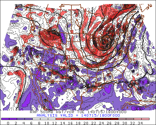
This event was well-modeled in the synoptic view. There was an anomalously strong upper level cutoff low moving into the Great Lakes. Ahead of this feature, there was a surface cold front advancing through Pennsylvania and New York with a pre-frontal/lee-side surface trough axis across New England by the morning of July 15th.
While this may sound like a good setup, as often is the case in this part of the country, many additional things have to line up just right. If one or two (or more) variables don’t pan out right, then the whole setup will likely underperform compared to expectations. Timing was also another issue, as with the cutoff low displaced so far west from New England, the best forcing would also remain further west.
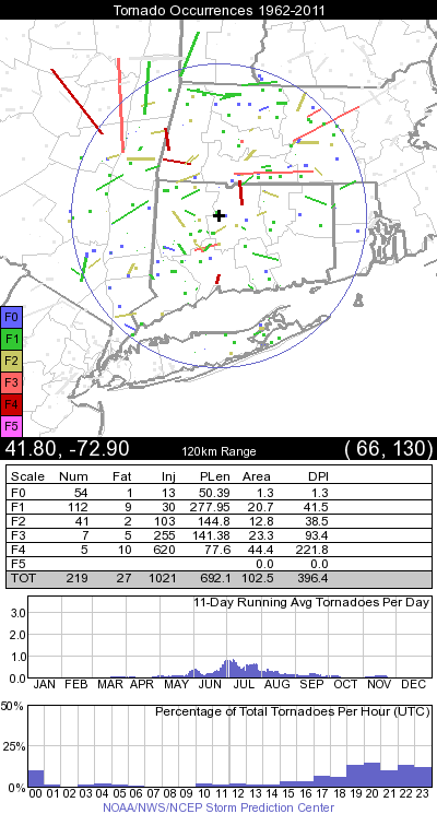
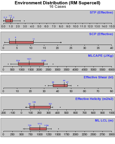
The mesoscale models were predicting anywhere from 500 to 1,250 J/kg of MLCAPE (with somewhat greater SBCAPE) coinciding with 30-40 knots of bulk shear across central New England and portions of western southern New England. While both parameters are what can be considered “elevated,” they are on the low end (lower 50 percentile) for what has been observed in the Northeast in prior tornado cases. When looking at severe producing supercells in general (all types/modes), the values mentioned above are actually even less significant. Consider that the mean bulk shear value for supercells in the southwestern New England window* is 44 knots with a mean MLCAPE value of 1,421 J/kg.
So, there were two key parameters in place that were elevated, but not terribly impressive in comparison to past severe events. There is another piece here that made the whole setup look even more marginal. Storm relative helicity or SRH (effective) was very meager on the computer forecast models for July 15th across most of the area. The progs were only between about 50 and 100 m2/s2. This is again on the low end, when considering that the mean SRH value for tornado and supercell cases alike in the area is 139 m2/s2 (which some cases over 300 m2/s2).
While looking at this forecast setup from a strict numerical standpoint, while the threat of tornadoes and other severe weather were somewhat elevated, it was clearly a “below average,” or in other terms, an “unimpressive” setup.
As far as the model simulated radar guidance, the NAM struggled to develop much in the way of discrete cell activity across southern New England, instead favoring a line of thunderstorms moving in from eastern New York by late afternoon and evening with stronger forcing ahead of the cold front. The HRRR was a bit more alarming, with a line strong to severe cells and clusters moving into southwestern New England by late afternoon. The HRRR by the 11z and 12z runs were showing some weak convection along the pre-frontal trough giving way to stronger convection further west later on.
The morning of July 15th:
Convection was already firing along the pre-frontal trough by midday, but due in part to limited heating, and weak forcing, the activity across Connecticut and south-central Massachusetts never reached severe limits. The HRRR continued to show stronger activity later in the day, but later runs gradually backed off on that idea. It was clear from the start that there was also a fairly unidirectional shear pattern with not much backing of low-level winds. Surface observations through the entire event, including the early to mid morning hours, showed surface winds S to SW.
It cannot be overlooked that a small area from northeastern Massachusetts into southeastern New Hampshire and much of Maine did see scattered strong to severe thunderstorms develop later on during the afternoon.
Analyzing the severe weather parameters on July 15th:
The models did a good job of predicting wind shear, as the SPC mesoscale analysis showed an average of about 40 knots of bulk shear across the area, with more across northern and northwestern sections and less across southern and southeastern sections. MLCAPE was also close to model guidance with generally 1,000 J/kg, on average. The pre-frontal activity did decrease instability across Connecticut with a noticeable uptick in CIN, especially in the vicinity of the trough. It was across northeastern Massachusetts and points northwest where less CIN and more significant SBCAPE values supported more in the way of storms being able to reach marginally severe limits.
Taking a step back, the mid-level lapse rates were fairly unimpressive across the area and this was acknowledged by SPC leading up to the event. The reanalysis showed lapse rates of 5.5 C/km or less across much of southern New England, with some lapse rates over 6 C/km across Maine.
Upper level considerations:
Analogs very strongly favored a relatively low-end severe event, especially given the position of the upper level low and the fact that the flow aloft was out of the SW. The RAP analysis from July 15th shows that the most significant vortmax was located very close to the upper level low, which was west of even western New York.  There was some positive vorticity advection across northern New England, which likely was a factor in boosting some of the severe thunderstorms north and northwest of Boston, Mass. The mesoanalysis showed a weak, elongated vortmax between 18z on the 15th and 00z on the 16th, but this was up across northern Vermont and the northwestern Maine/Canada border.
Finally, when also looking at the upper level flow, it was once again below climo levels with respect to significant severe events. The GYX and OKX soundings showed just 40 knots and 39 knots respectively of 500mb flow at 12z on the 15th. The upper level flow actually decreased notably at OKX to 31 knots by 00z on the 16th. While severe events can occur in the Northeast with limited upper level flow, the more impressive events typically have much stronger flow aloft. It should also be mentioned that the 850mb jet was unimpressive, with wind speeds of just 20 to 30 knots. Only one run of the Euro showed a signal of a strong jet and that was 144 hours prior, when it was predicting 45-55+ knots of 850mb flow.
The relatively weak flow and generally unidirectional shear pattern can be seen clearly in the 12z July 15th OKX sounding:

Considering the mesoscale models:
The HRRR performed poorly on the larger scale, as it did not show pre-frontal activity contaminating the environment across southwestern New England. Instead, it was more optimistic in terms of severe and even showed somewhat alarming significant tornado parameter values over 1 across much of Connecticut. Although some convection did cross over from Long Island into Connecticut, this wasn’t until late at night and most of that activity was marginally severe or below severe limits. Some fairly weak storms did fire across eastern New York by late afternoon, but those merged with other convection to form a very messy storm mode, one that favored training of heavy rains and flash flooding. The models also showed more backing of low-level winds than what was observed on the morning of July 15th and through the event.
In summary, what went wrong?
While it’s easy to blame the entire bust on early day convection across Connecticut, consider again the forecast parameters in place that verified very closely to the actual analysis. Instability was somewhat elevated, but still modest at best with around 1,000 J/kg of MLCAPE. Shear was also elevated, but 40 knots of bulk shear is somewhat below the average for past severe cases. One of the most glaring parameters missing from the equation was helicity. Helicity was expected and verified to be quite low on the spectrum, with 100 m2/s2 at best, while tornado activity favors more than that. With a SW flow aloft, a more strongly backed low-level wind profile would have supported a greater threat of severe. Instead, any backing was minimal, with the mean low-level wind flow being S to SW. It would have been one thing if mid-level lapse rates were impressive, to offset some of the other marginal parameters, but 5.5 C/km is not going to make up for everything else.
*


0 Comments
Recommended Comments
There are no comments to display.
Create an account or sign in to comment
You need to be a member in order to leave a comment
Create an account
Sign up for a new account in our community. It's easy!
Register a new accountSign in
Already have an account? Sign in here.
Sign In Now